Low stream flow delays fishing opener on Dungeness River
Flow in the Dungeness River is well below the average flow for early October, state officials said, leaving Dungeness Chinook salmon, an Endangered Species Act-listed stock within the Puget Sound area, particularly susceptible to disturbance during their spawning activities.
State officials anticipate a rainfall sufficient to restore the Dungeness' stream flow and draw coho salmon into the river will happen by Oct. 16; otherwise, the closure may be extended.
The County had been WARNED!
Praying for Rain Won't Help.
Clallam county has been warned over the years about the consequences of continued farmland conversion into residential and the impact on the water supply, they ignored it. This county seems hell bent on the continued destruction of the Sequim Dungeness Valley and the Dungeness River most recently through rezoning in Carlsborg to allow 4-14 dwelling units per acre. All the while the Pacific Coast Watershed Partnership and the The Dungeness River Management Team continue to seek funding to "Restore" the Dungeness River to " a closer copy of what it once was". THIS WILL NEVER HAPPEN! http://www.pacificwatersheds.net/ontheground/dungeness.htm The Dungeness River will never see it's former glory so go ahead and remove all the dikes and levees, they don't matter any longer.
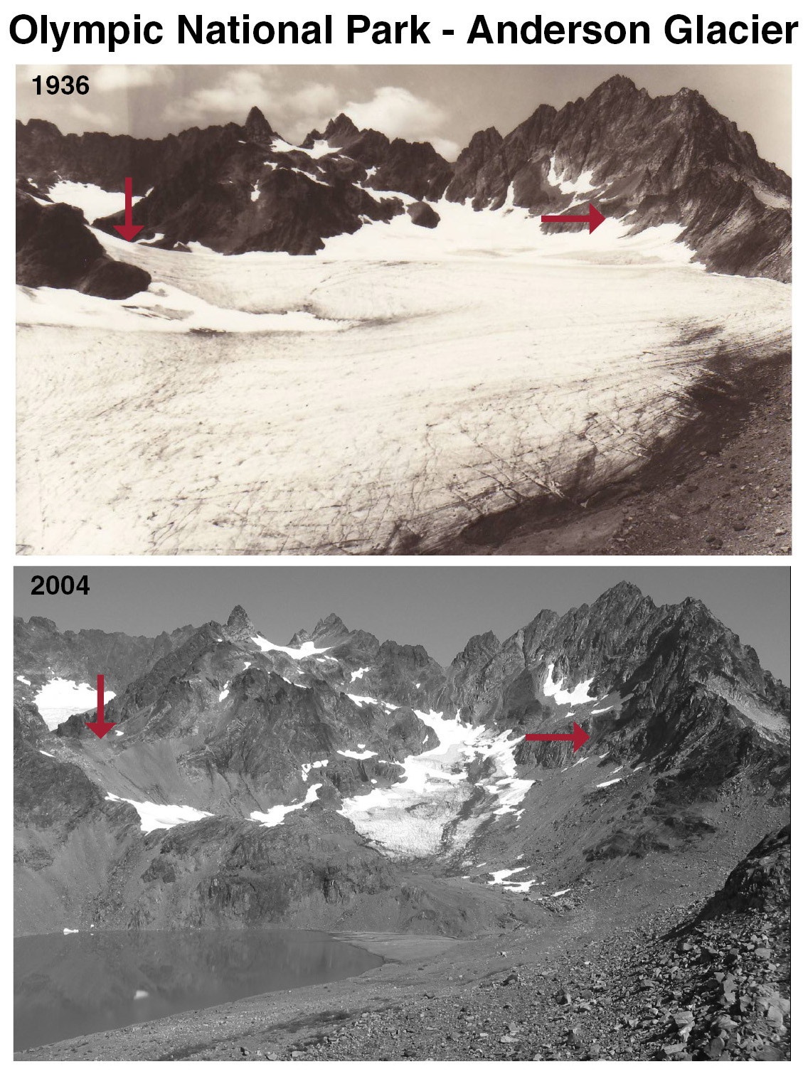
With the continuing decline in river water level due to the lack of rainfall, snow pack and the nearly depleted Anderson Glacier Their efforts will result in a zero outcome, it's just pouring money down the drain. (pun intended).

Comparison photographs show the dramatic retreat of Anderson Glacier.
1936: Asahel Curtis 2004: Matt Hoffman, Portland State Univ.
In one year from midnight October 1, 2013 to midnight October 1, 2014 the Cubic Feet Per Second (cfs) of the Dungeness River declined from 1,050cfs to 112cfs.
Everything the county and the "team" have done to the Dungeness River in the last 25 years has been contrary to competent river management. They have removed almost everything natural or man made that would slow the river and let it spread out into the side (lateral) channels that help support Raparian Areas that provide spawning habitat and vegetation and wildlife. Instead they have made it so that the river flows in the deepest channels with very little chance to spread to the side channels and support the raparian areas. See: Riparian Areas: Fish and Wildlife Havens
Sleeving the irrigation ditches thus drying up the shallow aquifer will lead to the Dungeness River as the MAJOR source of groundwater recharge leading to additional decrease of the in stream flow. One bad thing leads to another, the county's HUBRIS, GREED and COGNITIVE DISSONANCE of facts like those in the report below fully support my claims. Over Capitalization of Resources (over appropriated water) and Over Carrying Capacity of the Land (population) and damn the consequences, by all facts presented appear to be this county's MODUS OPERENDI.
THE WARNING
IMPACT OF CHANGES IN LAND USE ON THE
GROUND-WATER SYSTEM IN THE SEQUIM-DUNGENESS
PENINSULA, CLALLAM COUNTY, WASHINGTON
By B. W. Drost
U.S. GEOLOGICAL SURVEY
WATER-RESOURCES INVESTIGATIONS
REPORT 83-4094
Tacoma, Washington
1983
ABSTRACT
After 10-20 years of no irrigation, the model predicts that the water level in the water-table aquifer would have average declines of about 20 feet, some areas would become completely unsaturated, several hundred wells could go dry or nearly so, and leakage from the Dungeness River would become the major source of ground-water recharge. As of June 1980, ground-water quality in the study area has apparently not been affected by the use of on-site domestic sewage-disposal systems. The median nitrate-plus-nitrite (as N) concentration in the water-table aquifer was 0.35 milligrams per liter, and the maximum concentration was 2.5 milligrams per liter. (Emphasis Mine.)
In the Sequim-Dungeness peninsula, Clallam County, Washington, leakage from irrigation ditches is the most important source of ground-water recharge. Possible future land-use changes could lead to termination of the irrigation system. This would result in lower heads throughout the ground-water system, that could lead to well failures, increased pumping costs, seawater intrusion, and water-quality degradation. A digital-computer model was developed to simulate three-dimensional ground-water flow in aquifers underlying the peninsula in order to assess the impact of termination of the irrigation system. (Emphasis Mine.)
After 10-20 years of no irrigation, the model predicts that the water level in the water-table aquifer would have average declines of about 20 feet, some areas would become completely unsaturated, several hundred wells could go dry or nearly so, and leakage from the Dungeness River would become the major source of ground-water recharge. As of June 1980, ground-water quality in the study area has apparently not been affected by the use of on-site domestic sewage-disposal systems. The median nitrate-plus-nitrite (as N) concentration in the water-table aquifer was 0.35 milligrams per liter, and the maximum concentration was 2.5 milligrams per liter. (Emphasis Mine.)
The area has been extensively irrigated since about 1896 with water from the Dungeness River, which originates in the mountains to the south and flows through the middle of the area. Prior to irrigation, the area was sparsely vegetated and was subject to dry and barren summers
(Keeting, 1976). (Emphasis Mine.)
SUMMARY AND CONCLUSIONS
2. The model confirms that leakage from the irrigation system is the largest source of recharge to the ground-water system. The leakage occurs primarily from the ditch system, not from water actually applied to fields.
3. Termination of the irrigation system would lead to lower heads throughout the ground-water system. The ground-water levels in the water-table aquifer could have average declines of about 20 feet, and some areas could become completely unsaturated. Several hundred wells could go dry. (Emphasis Mine.)
3. Termination of the irrigation system would lead to lower heads throughout the ground-water system. The ground-water levels in the water-table aquifer could have average declines of about 20 feet, and some areas could become completely unsaturated. Several hundred wells could go dry. (Emphasis Mine.)